An Introduction to the DR Congo and Mayumbe
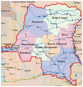
A former Belgian colony and an independent Republic since 1960, the Congo occupies the greatest part of the Congo basin. The country has as its borders –the Cabinda and the Congo enclave Brazzaville; to the Northeast, Sudan; to the East, Uganda, Rwanda, Burundi and Tanzania; to the South, Zambia and Angola. The estuary of the Congo (35Km) limits its sea front.
Inland, the Congolese depression is marshy and encircled by high plateaus. To the East, high mountains alternate (Ruwenzori, 5.120m) and depressions are formed by the Great Lakes of Albert, Kivu, Edouard and Tanganyika.
Lush forests cover these central regions which have a humid and hot equatorial climate. The confines of the country, due to their altitude, enjoy a less harsh climate. The fluvial network formed by the Congo River is cut by rapids. Its affluents are the Oubangui, the Kasaï, the Lomami and numerous rivers. Forests and savannas are home to diverse wild life.
In Congo there are more than two hundred ethnic groups speaking different languages and having their own customs.
The most important ethnic groups are the Bantus, then the Sudanese. Thereafter follow the Nilotics and also, as in Congo-Brazzaville, the wandering tribes of Pygmies.
The Congo is one of the richest African countries in mineral resources.
Congo’s modern history began in 1876, when the King of the Belgians, Léopold II, passionately fond of Stanley’s explorations, found in Brussels an African International Association in order to explore Black Africa and protect its populations against slavery. Soon afterward, Léopold II employed Stanley and sought to create a colonial territory, while Portugal claimed the mouth of the Congo and France claimed, through the intermediary of Savorgnan de Brazza, the Right Bank of the Congo and the Oubangui.
The International Conference of Berlin in 1885 elaborated for Africa the theory of the zones of influence. The Congo was declared independent under the personal government of the King of the Belgians. But the latter, incapable of meeting the expenses of this vast colony, he sold it to Belgium for twenty five million francs in 1908.
On 30 June 1960, the Belgian government granted independence to the Congo
- Area of the Congo: 2.345.000 Km2
- Population: more or less 45 million inhabitants
- Capital: Kinshasa
- Monetary unit: the Congolese Franc
- Languages spoken: French, Bantu dialects and Sudanese
When opening a geographic map, it’s easy to locate on the Atlantic coast of the African Continent the mouth of the Congo River. This is where, in the XV century, the Portuguese.
Navigators discovered, centered South of the river, the former kingdom of Congo, one of the post powerful countries of Central Africa. Later, the coast was left defenseless, as pirates and slave traders ravaged these regions and decimated the neighboring populations.
The popular narrations and legends have not, to date, clarified when the emigration to the North of the river of the important ethnic Yombe group took place.
Emigration, in any event, came prior to the Portuguese settling. It also appears that the mass of the Yombe population counts as its direct ancestry the former Congo kingdom. Nine of the Mayumbe tribes succeeded in crossing the Congo River and occupied without striking a blow almost the entire region lying between the Congo River and Tshiloango River. This is how they established themselves in the North of Boma in areas where they are still found today, between Cabinda and the ex-French Congo.
It is precisely in Boma in 1877 that Stanley completes his perilous journey across the “dark Continent”. Ten years later, the forces of the Independent State decided to occupy Mayumbe. Everywhere they encountered resistance of the stout populations. Several times, the latter victoriously resisted foreign invaders. The natives rose against the arrival of foreigners and strongly refused any occupation of the territory. This was because they were, for a long time, acquainted with the White man and his trading practices. They were neither fierce nor wild, or inhospitable. But experience taught them not to trust him and to face him with a tight, secret and united fist. It is only after 1894 that the resistance was quelled, with the governmental promise that the natives of Mayumbe would be stopped, until new orders, from reverting to public force.
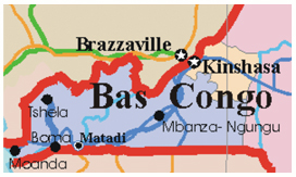
In 1895, the construction of a railway destined to link Boma to the Tshéla region, situated in the heart of Mayumbe, was started. The region is not without riches. With easy access to the sea, it soon became and remains to date one of the most prosperous of Central Africa. This region is in fact a real eldorado. Gold, diamonds, bauxite and silver are found. The equatorial forest overflows with rare essences and woodlands such as Wengé. Besides fisheries, the Atlantic Ocean supplies an offshore oil industry. The agro-industrial sector has always been prosperous. Coffee, cocoa, palm plantations abound. Among the most remarkable infrastructures of the region, are the Inga hydroelectric dam, Matadi harbor, the future deep-water port of Banana, Kinlao oil-refinery, in the coastal region, and the Kitona military base constructed in 1956.
An Introduction to the DR Congo and Mayumbe
A former Belgian colony and an independent Republic since 1960, the Congo occupies the greatest part of the Congo basin. The country has as its borders –the Cabinda and the Congo enclave Brazzaville; to the Northeast, Sudan; to the East, Uganda, Rwanda, Burundi and Tanzania; to the South, Zambia and Angola. The estuary of the Congo (35Km) limits its sea front.
Inland, the Congolese depression is marshy and encircled by high plateaus. To the East, high mountains alternate (Ruwenzori, 5.120m) and depressions are formed by the Great Lakes of Albert, Kivu, Edouard and Tanganyika.
Lush forests cover these central regions which have a humid and hot equatorial climate. The confines of the country, due to their altitude, enjoy a less harsh climate. The fluvial network formed by the Congo River is cut by rapids. Its affluents are the Oubangui, the Kasaï, the Lomami and numerous rivers. Forests and savannas are home to diverse wild life.
In Congo there are more than two hundred ethnic groups speaking different languages and having their own customs.
The most important ethnic groups are the Bantus, then the Sudanese. Thereafter follow the Nilotics and also, as in Congo-Brazzaville, the wandering tribes of Pygmies.
The Congo is one of the richest African countries in mineral resources.
Congo’s modern history began in 1876, when the King of the Belgians, Léopold II, passionately fond of Stanley’s explorations, found in Brussels an African International Association in order to explore Black Africa and protect its populations against slavery. Soon afterward, Léopold II employed Stanley and sought to create a colonial territory, while Portugal claimed the mouth of the Congo and France claimed, through the intermediary of Savorgnan de Brazza, the Right Bank of the Congo and the Oubangui.
The International Conference of Berlin in 1885 elaborated for Africa the theory of the zones of influence. The Congo was declared independent under the personal government of the King of the Belgians. But the latter, incapable of meeting the expenses of this vast colony, he sold it to Belgium for twenty five million francs in 1908.
On 30 June 1960, the Belgian government granted independence to the Congo
- Area of the Congo: 2.345.000 Km2
- Population: more or less 65.71 million inhabitants
- Capital: Kinshasa
- Monetary unit: the Congolese Franc
- Languages spoken: French, Bantu dialects and Sudanese
When opening a geographic map, it’s easy to locate on the Atlantic coast of the African Continent the mouth of the Congo River. This is where, in the XV century, the Portuguese.
Navigators discovered, centered South of the river, the former kingdom of Congo, one of the post powerful countries of Central Africa. Later, the coast was left defenseless, as pirates and slave traders ravaged these regions and decimated the neighboring populations.
The popular narrations and legends have not, to date, clarified when the emigration to the North of the river of the important ethnic Yombe group took place.
Emigration, in any event, came prior to the Portuguese settling. It also appears that the mass of the Yombe population counts as its direct ancestry the former Congo kingdom. Nine of the Mayumbe tribes succeeded in crossing the Congo River and occupied without striking a blow almost the entire region lying between the Congo River and Tshiloango River. This is how they established themselves in the North of Boma in areas where they are still found today, between Cabinda and the ex-French Congo.
It is precisely in Boma in 1877 that Stanley completes his perilous journey across the “dark Continent”. Ten years later, the forces of the Independent State decided to occupy Mayumbe. Everywhere they encountered resistance of the stout populations. Several times, the latter victoriously resisted foreign invaders. The natives rose against the arrival of foreigners and strongly refused any occupation of the territory. This was because they were, for a long time, acquainted with the White man and his trading practices. They were neither fierce nor wild, or inhospitable. But experience taught them not to trust him and to face him with a tight, secret and united fist. It is only after 1894 that the resistance was quelled, with the governmental promise that the natives of Mayumbe would be stopped, until new orders, from reverting to public force.
In 1895, the construction of a railway destined to link Boma to the Tshéla region, situated in the heart of Mayumbe, was started. The region is not without riches. With easy access to the sea, it soon became and remains to date one of the most prosperous of Central Africa. This region is in fact a real eldorado. Gold, diamonds, bauxite and silver are found. The equatorial forest overflows with rare essences and woodlands such as Wengé. Besides fisheries, the Atlantic Ocean supplies an offshore oil industry. The agro-industrial sector has always been prosperous. Coffee, cocoa, palm plantations abound. Among the most remarkable infrastructures of the region, are the Inga hydroelectric dam, Matadi harbor, the future deep-water port of Banana, Kinlao oil-refinery, in the coastal region, and the Kitona military base constructed in 1956.
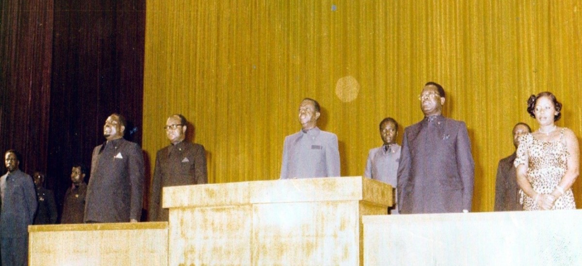
© Marie-rose Kasavubu
An Introduction to the DR Congo and Mayumbe
A former Belgian colony and an independent Republic since 1960, the Congo occupies the greatest part of the Congo basin. The country has as its borders –the Cabinda and the Congo enclave Brazzaville; to the Northeast, Sudan; to the East, Uganda, Rwanda, Burundi and Tanzania; to the South, Zambia and Angola. The estuary of the Congo (35Km) limits its sea front.
Inland, the Congolese depression is marshy and encircled by high plateaus. To the East, high mountains alternate (Ruwenzori, 5.120m) and depressions are formed by the Great Lakes of Albert, Kivu, Edouard and Tanganyika.
Lush forests cover these central regions which have a humid and hot equatorial climate. The confines of the country, due to their altitude, enjoy a less harsh climate. The fluvial network formed by the Congo River is cut by rapids. Its affluents are the Oubangui, the Kasaï, the Lomami and numerous rivers. Forests and savannas are home to diverse wild life.
In Congo there are more than two hundred ethnic groups speaking different languages and having their own customs.
The most important ethnic groups are the Bantus, then the Sudanese. Thereafter follow the Nilotics and also, as in Congo-Brazzaville, the wandering tribes of Pygmies.
The Congo is one of the richest African countries in mineral resources.
Congo’s modern history began in 1876, when the King of the Belgians, Léopold II, passionately fond of Stanley’s explorations, found in Brussels an African International Association in order to explore Black Africa and protect its populations against slavery. Soon afterward, Léopold II employed Stanley and sought to create a colonial territory, while Portugal claimed the mouth of the Congo and France claimed, through the intermediary of Savorgnan de Brazza, the Right Bank of the Congo and the Oubangui.
The International Conference of Berlin in 1885 elaborated for Africa the theory of the zones of influence. The Congo was declared independent under the personal government of the King of the Belgians. But the latter, incapable of meeting the expenses of this vast colony, he sold it to Belgium for twenty five million francs in 1908.
On 30 June 1960, the Belgian government granted independence to the Congo
- Area of the Congo: 2.345.000 Km2
- Population: more or less 45 million inhabitants
- Capital: Kinshasa
- Monetary unit: the Congolese Franc
- Languages spoken: French, Bantu dialects and Sudanese
When opening a geographic map, it’s easy to locate on the Atlantic coast of the African Continent the mouth of the Congo River. This is where, in the XV century, the Portuguese.
Navigators discovered, centered South of the river, the former kingdom of Congo, one of the post powerful countries of Central Africa. Later, the coast was left defenseless, as pirates and slave traders ravaged these regions and decimated the neighboring populations.
The popular narrations and legends have not, to date, clarified when the emigration to the North of the river of the important ethnic Yombe group took place.
Emigration, in any event, came prior to the Portuguese settling. It also appears that the mass of the Yombe population counts as its direct ancestry the former Congo kingdom. Nine of the Mayumbe tribes succeeded in crossing the Congo River and occupied without striking a blow almost the entire region lying between the Congo River and Tshiloango River. This is how they established themselves in the North of Boma in areas where they are still found today, between Cabinda and the ex-French Congo.
It is precisely in Boma in 1877 that Stanley completes his perilous journey across the “dark Continent”. Ten years later, the forces of the Independent State decided to occupy Mayumbe. Everywhere they encountered resistance of the stout populations. Several times, the latter victoriously resisted foreign invaders. The natives rose against the arrival of foreigners and strongly refused any occupation of the territory. This was because they were, for a long time, acquainted with the White man and his trading practices. They were neither fierce nor wild, or inhospitable. But experience taught them not to trust him and to face him with a tight, secret and united fist. It is only after 1894 that the resistance was quelled, with the governmental promise that the natives of Mayumbe would be stopped, until new orders, from reverting to public force.
In 1895, the construction of a railway destined to link Boma to the Tshéla region, situated in the heart of Mayumbe, was started. The region is not without riches. With easy access to the sea, it soon became and remains to date one of the most prosperous of Central Africa. This region is in fact a real eldorado. Gold, diamonds, bauxite and silver are found. The equatorial forest overflows with rare essences and woodlands such as Wengé. Besides fisheries, the Atlantic Ocean supplies an offshore oil industry. The agro-industrial sector has always been prosperous. Coffee, cocoa, palm plantations abound. Among the most remarkable infrastructures of the region, are the Inga hydroelectric dam, Matadi harbor, the future deep-water port of Banana, Kinlao oil-refinery, in the coastal region, and the Kitona military base constructed in 1956.
Ancienne colonie belge, République indépendante depuis 1960, le Congo occupe la plus grande partie du bassin du Congo. Le pays a pour frontières, à l’Ouest, l’enclave du Cabinda et le Congo – Brazzaville, au Nord-Est le Soudan, à l’Est l’Ouganda, le Rwanda, le Burundi et la Tanzanie, au Sud la Zambie et l’Angola.Sa façade maritime est limitée par l’estuaire du Congo (35Km).
Au centre, la cuvette congolaise, marécageuse, est encerclée par de hauts plateaux. A l’Est, alternent de hautes montagnes (Ruwenzori , 5.120 m) et des dépressions formées par les grands lacs Albert, Kivu, Edouard et Tanganyika…
Les régions centrales qui connaissent un climat équatorial humide et chaud sont couvertes de forêts exubérantes.Les confins du pays, en raison de leur altitude, jouissent d’un climat moins pénible.Le réseau fluvial formé par le fleuve Congo, est coupé de rapides. Ses affluents sont l’Oubangui, le Kasaï, le Lomami et d’innombrables rivières. Forêts et savanes abritent une faune diversifiées.
On trouve au Congo plus de deux cents groupes ethniques parlant des langues différentes et ayant leurs propres coutumes.
Les ethnies les plus importantes sont celles des Bantous, puis des Soudanais. Viennent ensuite les Nilotiques et aussi, comme dans le Congo-Brazzaville, des tribus errantes de Pygmés.
Le Congo est l’un des pays africains les plus riches en resources minières.
L’histoire moderne du Congo commence en 1876 lorsque le roi des Belges , Léopold II , passionné par les explorations de Stanley, fonde à Bruxelles une Association Internationale Africaine afin d’explorer l’Afrique noire et protéger ses populations contre l’esclavage. Peu après, Léopold II prend Stanley à son service et cherche à se constituer un domaine colonial, tandis que le Portugal revendique l’embouchure du Congo et que la France fait reconnaître par Savorgnan de Brazza la rive droite du Congo et de l’Oubangui.
La Conférence internationale de Berlin de 1885 élabore pour l’Afrique la théorie des zones d’influence.Le Congo est déclaré indépendant sous le gouvernement personnel du roi des Belges. Mais ce dernier, incapable de faire face aux dépenses de cet immense domaine colonial, le vend à la Belgique pour vingt-cinq millions de francs en 1908.
Le 30 juin 1960, le gouvernement belge octroie l’indépendance au Congo.
- Superficie du Congo : 2.345.000 Km2
- Population : plus ou moins 65.71 millions d’habitants
- Capitale : Kinshasa
- Unité monétaire : le Franc congolais
- Langues parlées : le français, les dialectes bantous et soudanais.
Lorsque l’on déploie une carte géographique, l’on repère sur la côte atlantique du continent africain l’embouchure du fleuve Congo.C’est ici qu’au XVème siècle, les navigateurs portugais découvrirent, centré au Sud du fleuve, l’ancien royaume Kongo, l’un des plus puissants de l’Afrique centrale.Plus tard, la côte fut livrée sans défense aux écumeurs des mers et aux esclavagistes qui ravagèrent ces régions et décimèrent les populations avoisinantes.
Les récits populaires et les légendes n’ont pas permis jusqu’ici d’éclairer à quelle époque se fit l’émigration au Nord du fleuve de l’important groupe ethnique Yombe. L’émigration fut antérieure en tout cas à la colonisation portugaise. Il semble acquis également que la masse de la population Yombe compte
ses ascendants directs dans l’ancien royaume Kongo.Neuf des clans du Mayumbe réussirent à passer le fleuve Congo, occupèrent sans coup férir presque toute la contrée comprise entre le fleuve Congo et le fleuve Tshiloango. C’est ainsi qu’ils s’établirent au nord de Boma dans les lieux où on les trouve encore
aujourd’hui, entre le Cabinda et le Congo ex-français.
C’est à Boma précisément qu’en 1877, Stanley termine son périlleux périple à travers le ” continent sombre “.Dix ans plus tard, les forces de l’ Etat indépendant décidèrent d’occuper le Mayumbe.Partout, elles se heurtèrent à une résistance opiniâtre de la part des populations. A maintes reprises, celles-ci résistèrent victorieusement à la pénétration étrangère.Les indigènes s’insurgèrent contre l’arrivée des étrangers et se refusèrent avec énergie à toute occupation du territoire. C’est qu’ils connaissent le Blanc de longue date, et ses trafics. Ils ne sont ni farouches, ni sauvages, encore moins inhospitaliers. Mais l’expérience leur a enseigné à ne pas lui faire confiance et à se présenter devant lui comme une main fermée , secrète et unie.Il faudra attendre 1894 pour que la résistance s’apaise, sur la promesse gouvernementale que les indigènes du Mayumbe seront, jusqu’à nouvel ordre, dispensés du recours à la force publique.
En 1895, la construction d’un chemin de fer destiné à relier Boma à la localité de Tshéla sise au cœur du Mayumbe, est entreprise. La contrée ne manque pas de richesses. Avec un débouché facile sur la mer, elle deviendra bientôt et demeurera jusqu’à nos jours une des plus prospères de l’Afrique centrale.Cette
région est en effet un véritable eldorado. On y trouve de l’or, du diamant, de la bauxite, de l’argent. La forêt équatoriale regorge d’essences rares, de bois tel que le Wengé.Outre les ressources halieutiques, l’océan atlantique fournit du pétrole off-shore. Le secteur agro-industriel a toujours été prospère dans la région. Les plantations de café, de cacao, des palmeraies foisonnent.
Parmi les infrastructures les plus remarquables de la région, on doit citer le barrage hydro-électrique d’Inga, le port de Matadi, le futur port en eau profonde de Banana, la raffinerie de pétrole de Kinlao, dans la région côtière, la base militaire de Kitona construite en 1956.
© Marie-rose Kasavubu